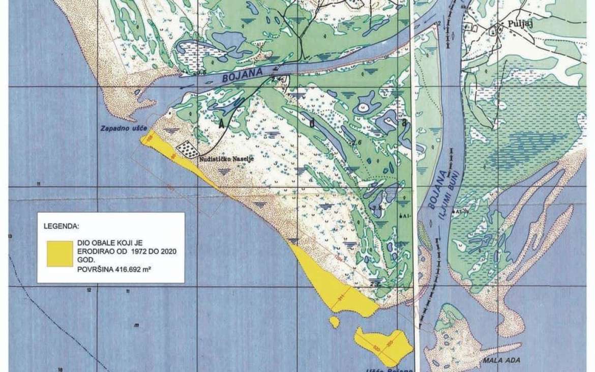

November 22, 2020 - The belt between the left and right arms of Bojana, which includes today's nudist beach Ada Bojana, has shrunk by almost 420,000 square meters in half a century. More precisely, from 1972 until today, the area of the beach that could hold 60 average football stadiums has disappeared, which is the epilogue of intensive erosive processes and reduced natural feeding of beaches, according to research by the Institute of Hydrometeorology and Seismology.
The Sector for Hydrography, Oceanography, and Seismology participated in the preparation of the Study of Preservation and Revitalization of the Beach on Ada Bojana, carried out by prof. Dr. Sava Petkovic from Belgrade and which should be adopted by the end of this year. With this study, the beaches of Ada Bojana could be saved from erosion and restored to their previous state.
In the meantime, as Pobjeda wrote, prof. Petković will take short-term measures to protect Ada Bojana from further erosion, which would be implemented by the public enterprise Morsko Dobro.
Origin and erosion of Ada Bojana
As the head of this sector, Radovan Kandic, said, the process of the disappearance of Ada Bojana beach is a circumstance that, unfortunately, we have been facing for many years.
- Historically, the origin of Ada Bojana and the intensive feeding of the Grand Beach is related to the period 170 years ago. The penetration of the Drim river into the Bojana riverbed, which brought a large amount of sand in Bojana, and the action of sea currents dispersed it along the Grand Beach on one side and increased the area of Ada Bojana and create its beach on the other - explains Kandic.
He adds that the construction of reservoirs on the Drim has significantly reduced the inflow of soft material, so Ada Bojana and the Grand Beach lost a large part of their natural food, from where they pumped sand and fed the beach for years.
- Also, natural circumstances, primarily the action of the Coriolis force of deviation, cause the undermining of the left bank of the left arm of Bojana. Therefore, the mother of the river is in the left tributary, which additionally affects the reduced water flow in the right - said Kandic in the interview for the daily Pobjeda.
Kandic also notes that the agreement between the Republic of Albania and Montenegro defines that the average annual flow in the right arm should be 25 percent and in the left arm 75 percent.
- Unfortunately, the natural process significantly reduced the flow in the right arm. According to the latest measurements, it is about 11 percent, which leads to a significant slowdown of Bojana at the mouth of the sea, and thus prevents further malnutrition of Ada Bojana and the Grand Beach - explains Kandic.
According to him, the preparation of a study for the preservation and revitalization of the beach on Ada Bojana is an extremely complex project, being realized in two phases.
- In the first phase, research works were carried out, which include geodetic surveying of the mainland of the Grand Beach, geological sampling of surface sediments, and bathymetric survey of the water area defined by the project. The second phase of the project is the development of a model of wave propagation from deep to shallow water, and as a summary of everything, future measures and actions are proposed to preserve the beach from further disappearance and devastation - explains Kandic.
As he added, the Sector for Hydrography and Oceanography participated in a part of the research works, performing a bathymetric survey. He provided logistics during geological sampling for the needs of granulometric analysis and support with already existing data, necessary for the realization of the second phase of the project.
A bathymetric survey measured an area of about 3,000 hectares, from the coastline to the isobaths of 20 meters, said Kandic. The Institute of Hydrometeorology and Seismology is in charge of permanent hydrographic and hydrological monitoring of the river Bojana.
- In the past two years, a bathymetric survey was carried out three times, and four times colleagues from the Sector for Hydrology measured the flow on the part of the right arm, all the way to the mouth of the Bojana into the sea - claims Kandić. Besides the newly completed survey, the Institute also provided support with the already existing hydrographic, hydrological, oceanographic, and meteorological data.
After the completion of the study, entrusted to Professor Sava Petkovic, the final and definitive causes of erosion of Ada Bojana and the Grand Beach will be obtained. The document will define the measures to preserve the current situation and prevent further erosion, which would undoubtedly lead to its complete disappearance.
Constant monitoring of Ada Bojana will be needed
- The Institute of Hydrometeorology and Seismology, as before, will provide all kinds of professional and scientific assistance to solve this problem. The study will prescribe certain measures and actions that will require the constant engagement of our professional staff for further collection of hydrological, hydrographic, and oceanographic data. Those are a necessary condition for all future studies and analyzes, i.e., establishing monitoring on the entire course of Bojana and its tributaries - says Kandic.
Source: Pobjeda